Tuesday, July 23, 2024

Canada - Day 41 - Deception Bay to Bellingham

39.3 miles, 1627’ climbing, deer

We packed up early and left the Deception Bay campground before most other campers were up. From the Deception Pass bridge, we could see the water below flowing quickly and swirling with a strong current. It looked like the tide was going out. 


We hopped on the shoulder of the busy highway 30 for several miles before turning off on quieter side roads. Near Anacortes we had breakfast sandwiches and coffee at a coffee house. A local road biker tipped us off on the safest way to get across the Swinomish bridge, and then we headed up the coast on a trail near the south Padilla wildlife area. Roads were pretty quiet, and the riding pretty easy. At Larabee State Park we turned off Chuckanut Drive and onto the interurban trail. This took us right to Sarah’s sister’s house and the end of our bikepacking trip. 


Monday, July 22, 2024

Canada - Day 40 - Eaglemont Rockery to Deception Bay

47.5 (5.5 on ferry) miles, 2001’ climbing, deer

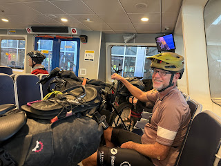
We had a dozen or so miles to our ferry in Port Townsend, and we knew it didn’t leave until 11am due to the tides. For 4.5 miles, we were back on the road with no shoulder and a lot of traffic. When a dump truck breezed past our elbow, we could see that the driver was trying to give us space, but due to oncoming traffic and narrow lanes, there was no space to give. We were glad to turn off onto a less travelled road and finally a trail into town. We had breakfast at the Blue Moose Cafe, pumped our tires at a local bike shop and cleaned our drive trains, then finally boarded the ferry to Coupeville along with 10 other bike travelers.


After leaving the Coupeville ferry, we were on a charming road between the east and west coasts of Whidbey Island. The breeze, the clapboard houses, and the feel of the place made us think of New England, a different feel than Vancouver Island or the Olympic Peninsula. 


We passed through Coupeville and headed up the coast. Near the town of Oak Harbor, we ended up on the highway shoulder with a lot of traffic, and the riding was less enjoyable. We picked up some groceries, then continued up the highway to Deception Bay. The campground was fully booked, but they have hiker/biker sites which are available without reservation to those not arriving by way of car, and we were the only people doing that today. 


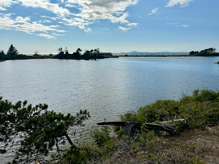
Cranberry Lake is separated from the ocean (straits of San Juan de Fuca?) only by a spit of land. We walked down along the lake and then the dramatic west and north beaches of Whidbey Island, next to our camp site.  It’s a beautiful place to camp.


Tomorrow this ride ends, which we both look forward to and are sad about. Sarah handed off her bear spray and threw the dreaded blue shirt in the garbage, the shirt that stretched and looked weird, was hot in the sun but not warm in cool weather, that was slow to dry, and that she spilled food on repeatedly. Adios, dreadful blue shirt. Throwing it out felt great.


Sunday, July 21, 2024

Canada - Day 39 - Victoria to Eaglemount Rockery

 64.9 miles, 2096’ climbing

Our ferry didn’t leave Victoria until 10:30, so we had an unhurried morning. By chance, the Canadian National criterium races were being held right by our hotel and the ferry dock starting at 8am. We saw two of the women’s masters races before we boarded the ferry for Port Angeles. The ferry took about 1.5 hours, and we docked at noon then proceeded through customs and stopped at the local grocery store.


At 1pm we finally got on our bikes headed towards Port Townsend. For around 35 miles, we were on the largely paved Olympic Discovery Trail, completely separated from traffic most of the time. It passed through some neighborhood streets in Sequim where a lavender festival was being held in a park, tons of crafts and food booths. We stopped for a Coke and a snack.


After ~35 miles, our ride went onto the side shoulder of the highway. We stopped for dinner at Fat Smitty’s, a burger joint with dollar bills all over the ceiling and walls.


The last two miles of our ride were up a narrow two lane highway with no shoulder, and a drop off into a deep ditch at the edge of the pavement. There was a fair amount of fast traffic, not fun, but we arrived at our charming rental cottage at Eaglemont Rockery. There was a great view of Discovery Bay as well as historic plaques, old buildings, and some models, products of somebody’s quirky hobby.


Saturday, July 20, 2024

Canada - Day 38 - Malahat to Victoria

25.7 miles, 1095’ climbing

Our hotel in Malahat was on a busy highway with fast traffic, so we looked for a quiet road to return to our route, and we thought we found a good candidate. It should be a short, easy day of riding into Victoria. 


When we turned off for the forest road to go back to our track, two large dogs ran out into the street, barking, a pit bull and a Rhodesian ridgeback with no collars. We stopped and put our bikes between ourselves and them, hard to tell if they might actually bite. A woman came out and started yelling at the dogs (they ignored her) followed by a smiling guy who looked like Charles Manson. They said the road was private and told us to leave which we did immediately. It was not a fun start.


The highway ride to Langford was loud with traffic that was sometimes close, but it went pretty quickly. We passed a coffee house near a bike pump-it track as we rejoined our route. There were lots of cyclists including small kids on the pump-it track, one on a balance bike (cute), breakfast and coffee were good.


From Langford, we got on a bike path that took us all the way into Victoria. We passed huge hotels and boats along the shore line, circled to Mile Zero Beach (photo op), and pedaled to the top of Beacon Hill, the official start of the Great Northern Bikepacking Route which we’ve been partially riding in reverse. 


We had a lazy day in the touristy part of Victoria. Tomorrow we catch a ferry back into the US. It will be about 3 more days back to Bellingham.


Friday, July 19, 2024

Canada - Day 37 - Lake Cochiwan Campsite to Malahat

56.8 miles, 2234’ climbing, deer, bald eagle

Rolling out of our campground, we were back on the gravel road from yesterday with a lot of traffic, including logging trucks. After 10 miles, we turned onto smooth asphalt, still along Lake Cochiwan. At Golden Bay, we stopped at a small store and then at a coffee shop across the street. We had a great home-cooked breakfast.


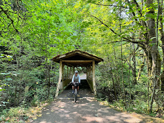
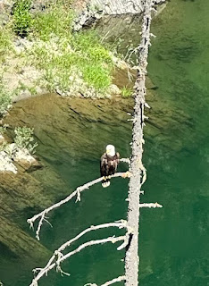
We continued on asphalt with traffic until the 20 mile mark in the town of Lake Cochiwan, we turned off on the Cochiwan Valley Rail Trail. It turned into 30 miles of easy riding — a good surface with no steep ups or downs. We saw a number of other cyclists and hikers, and from one of the trestle bridges we saw a bald eagle perched above the river below. 


After 50 miles, the rail trail ended, and our route took us onto a dirt track with some hills. We then took done side roads go a hotel in Malahat since there were no hotel or camping options along the route Sherwood we wanted to stop. 


Tomorrow should be a shorter day into Victoria. We booked a hotel since it is the weekend, and we booked a ferry to Port Angeles for the following day. As we near the end of our bike ride, we are looking forward to seeing family, wearing different clothes, and taking some days off from cycling. 


Thursday, July 18, 2024

Canada - Day 36 - Port Alberni to Cowichan Lake

 59.4 miles, 3441‘ climbing, ducks

The day was forecast to be cooler, so we took our time getting started. The only breakfast option was McDonald’s, so there we went. Our ride back to the route was up a steep hill. Soon we turned onto trails through the woods, up and down for a couple miles. The following 30 miles or so were on a paved road with a layer of gravel on it, into a headwind. For some reason there was a good amount of traffic. The next 10 miles had one paved lane, soft shoulders, and high speed drivers into a head wind. Our final 10 miles had a tailwind, but still people driving fast and close. Where were all these drivers coming from and headed to? Hard to figure out. It wasn’t great riding today, but in the end we found a lovely campsite. We picked a lot of thimbleberries which we ate before dinner. It should be 2 medium-short days to Victoria. 


Wednesday, July 17, 2024

Canada - Day 35 - Cumberland to Port Alberni

 57.5 miles, 2582’ climbing, deer

We rose early, knowing the forecast was for temperatures just under 90F. We were also concerned after hearing that a forestry management company closed a lot of roads which might affect our ability to ride to our destination. It’s a long story, a huge portion of Vancouver Island is private land, here’s a link if you’re interested: https://www.openthegates.ca/


We rode thru the forest for around 10 miles to Royston on the east coast of the island. Then we mainly rode on the shoulder of a paved road down to Qualicum Bay. The best sight was the Fanny Bay Inn, sorry we didn’t snap a photo. Their sign is in the shape of a badge and says FBI. 


We headed inland along the Big Qualicum River, planning a swim somewhere but we never identified our spot. Soon we were alongside the beautiful Horne Lake which the river comes out of. We rode half a dozen miles to the west end and had a swim. There was a beautiful campground: shady sites with tall trees, potable water, a large beach, a concession that rented paddle boards, kayaks, and canoes, nearby caves to be toured. The afternoon was hot and we were very tempted to stay, but we headed onwards after our swim.


We had a five mile climb before we descended to Port Alberni. We did go past a few signs saying the road was closed and to stay out. There were lots of bike and ATV tracks, but we didn’t see a single person, so it was hard to assess whether they just meant to keep cars out or if they meant hikers and cyclists, too. We had no alternate, so we proceeded. The last mile was a small steep track and a rough road that we pushed our bikes up. It was a steep descent to Port Alberni where we booked a hotel and did our town chores: laundry, groceries, showers, food. We were not in a charming part of town, but the local business people were friendly and kind.


Tuesday, July 16, 2024

Canada - Day 34 - Powell River to Cumberland

 47.1 miles (19 on ferry), 1362’ climbing, deer and more than a dozen bald eagles

We’ve had a lot of beautiful and fun days on this trip, but today may be the best for fun riding even though the miles were short.


We were up early to make sure we were able to board the Powell River - Comex ferry. This is a longer ride, and rules seemed stricter than on many of the bc ferries. We were able to grab a scone and coffee before waiting to board. The ride was 19 miles and an hour and 40 minutes plus all the time to board and unboard. It was past 10am when we started pedaling away from the Comex terminal on Vancouver Island.


Almost immediately, we turned off on a small path, somewhat overgrown, lined with thimbleberries, it took us to a neighborhood street and then to a path that felt like something established by the neighborhood kids. We had a few miles on pavement, and then we were back on flowy singletrack through the woods, easy and fun, winding around trees, sometimes coming through sunny patches lined with ferns and berry bushes. And so our day went, circling the town of Courtenay without going in, lots of fun singletrack. The neighborhood roads had small farms advertising eggs and berry picking. We made one stop to pick wild thimbleberries, then we rode alongside a beautiful river for a few miles. We saw a few people, but it was peaceful and uncrowded and away from traffic.


The river flowed out of Comox Lake, and we stopped for a swim below the dam. After about an hour, we got back on our bikes. We saw a couple more fabulous swimming holes before heading back into the woods. Eventually we ended up on “the old dump road” into Cumberland, a couple miles of gravel that did indeed pass a dump site. Overhead we spotted two bald eagles, then two more, then at least a dozen. They soared overhead and perched in tall fir trees. Were they scavenging at the dump? From there it was smooth pavement into town where we booked a room at the Riding Fool’s hostel. Cumberland is a small, funky town with a lot of bike infrastructure. It’s 87F here, so plenty warm.


Monday, July 15, 2024

Canada - Day 33 - Seabreeze Campsite to Powell River

17 miles, 1421’ climbing, deer

We decided to take a short day to relax a bit out of the sun. After 9 miles of climbing on a gravel road, we turned off towards Duck Lake which indeed had 1 duck. We were close to the shore, but only got glimpses of it through the dense foliage. Finally we came to a break in the trees and got the view. We continued onto some narrow, uphill singletrack that twisted through a lot of mossy tree stumps, challenging on loaded gravel bikes.


Soon we reached a downhill towards Powell River. We stopped at the beautiful Cranberry Lake, half covered with blooming water lilies. Arriving in town, we had a late breakfast. We booked a cute, retro motor hotel near the center of town, doing our laundry, shopping, and bike chores. The local bike shop let us use their floor pump, always nicer than hand pumping our tires. The Sunshine Coast seems to have a strong mountain bike community with tons of trails. 


The Sunshine Coast has come through for us with the all day sun. A long day outdoors is a lot of sun even when the riding isn’t too hard, not like Tucson, but it’s plenty of sun. Tomorrow we take the ferry to Vancouver Island. We hope the good weather will continue.


Sunday, July 14, 2024

Canada - Day 32 - Sechelt to Seabreeze Campsite

 55.7 miles, 4186’ climbing, deer

When you spend the night at sea level, you’re almost certainly going to start your morning with a climb. 


We started riding early and after a few miles of uphill pavement, we turned onto forest singletrack. 


The forest was so dark that we had to swap our sunglasses for clear glasses. We passed through ferns and large trees and mossy stumps. We wove in and out of roads and trails, at one point finding ourselves on a steep, narrow up hill trail where we had to push our bikes up over roots, beautiful but hard work. Sensing our weakness, the mosquitos converged. We came to a bridge, half of which was a large log, easy to walk across but tricky with a loaded gravel bike given the rocky creek you would land on below if you wobbled.


After some road riding, we arrived at the Sunshine Coast Earl’s Cove ferry landing. It was almost 2 hours until the ferry would come, and fortunately there was a shady deck we could wait on sipping cool drinks from the cafe. The ferry to Powell River to Saltery Bay took another 50 minutes.


After the ferry we pedaled on the highway shoulder in the humid sun to the Lois River where we descended to Eagle River Falls, taking a swim in the pool above the main falls. A further mile down the road was a small store where we picked up a little food, then we continued to the nearby Seabreeze Resort, a small, family-run campsite and cabin rental. After setting up our tent, taking showers, and cooking our ramen, we walked along the rocky beach. The location was beautiful, and the cool air was perfect for sleeping in the tent.


Saturday, July 13, 2024

Canada - Day 31 - Vancouver to Sefelt

 61.4 miles (some done on ferries), 3822’ climbing, deer, otter (kinda), heron

The air was cool and pleasant, and traffic was still minimal, as we left the Holiday Inn in Vancouver. It was the last day of our bypass-the-heat route which skipped northern BC in order to reach the cool breezes on the coast. It’s part of a trans-Canada route somebody rode in the opposite direction. The Trans-Canada route is known for being disjointed and incomplete, but it has put us on a lot of trails that avoid traffic, something we appreciate. Because the direction is reversed from the original, we have awkward route finding on one way streets, usually but not always simple to solve. Vancouver has a ton of cycling infrastructure, awesome but not always immediately clear to the out-of-town visitor.


This morning our route had a sight-seeing aspect. We pedaled around the Vancouver inlet, then expected to circumnavigate the beautiful Stanley Park. Soon we realized that we were headed the wrong way on a one-way path, an artifact of our reversed route. We backtracked, cut across trails, dodged traffic, eventually found a place for breakfast and caught the Waterfront to Lonsdale ferry for North Vancouver. 


North Vancouver immediately seemed more peaceful than the main part of town. Our route took us uphill along creeks, then we crossed a dam where a 10k race was being held. The path climbed and climbed, eventually reaching a fancy neighborhood where mansions had views of the harbor or possibly just trees and hedges which were most of what we could see. The steep climbs went on seemingly forever, then descended switchbacks. We thought the route was designed to show us a fancy neighborhood, but otherwise it didn’t seem like a reasonable route choice.


The road to the horseshoe bay was a mess, leading us up and down staircases, across what seemed to be private property. Finally we googled a route to the ferry, and we had to ride on the freeway shoulder for a couple kilometers. Not great, but we immediately boarded the ferry with around 10 other cyclists, enjoying the beautiful views up to the Sunshine Coast. On the recommendation of a local from Toverts Creek who was on the ferry, we rode into Gibson’s Bay for lunch. Then an up-and-down road took us up the coast. We stopped for an ice cream at a beach, and an otter was swimming in the waves, but we only caught a brief glimpse. We had booked a Sechelt hotel since it’s the weekend. It’s very comfortable, but the day felt long.